Tuesday, November 5, 2013

Kaupo and Pi'ilanihale Heiau


My intention was to go out to Nu'u and beyond—to the coconut grove where Kekaulike lived. Sahlins and Kirch claim that whole area—from Nu’u to Kaupo--was the largest sweet potato growing area in the islands because of the soil from the alluvial fan spread down the mountainside from the Kaupo Gap. I had thoroughly intended to explore the area--and actually got out of the car and took some photos at one point, but I ended up getting back in the car and continuing.  The road to Hana winds around the
coastline--very narrow in some places with signs that say "Honk" before you venture around a sharp corner/boulder and run smack into an oncoming vehicle.


I stopped on the bridge for a picture of the waterfall--surprised when I later realized it was the only waterfall I was to really see all day. When I mentioned it, I heard that there has been a drought and that the usual waterfalls all along the windward coast of Maui were barely trickling.  

I stopped to eat my egg salad sandwich at Waianapanapa State Park but I didn't even get out of the car--something kept pressing me to go on down the road.  I passed the sign for Kahanu Botanical Gardens and said, "Hey! That's where Pi'ilanihale Heiau is!"  And I turned around. I drove down the road, not stopping at the lava tube but going straight to the gardens.  I got out of the car to pay and ended up chatting with the nice lady. Finally she said, "You'd better get going."

 
I drove down the cement trail to where the cars park and was taking my time strolling through the gardens--looking at the red sugar cane--wondering how and when I was going to see the heiau. I looked up and actually had one of those "Oh My God!" moments. That rock structure is enormous! In my travels I've not seen anything like it--I've seen heiaus that have been reconstructed--Puukohala comes to mind--up there on the side of the hill at Kawaihae--that has been rebuilt with the help of the National Park Service. Although grand, it does not compare to Pi'ilanihale--which has stayed and has been cared for by the Pi'ilani family. 


I wanted to see if I could get the whole length of the structure in one picture and walked out to the lawn, but even then it was not possible. 


The clouds were rolling off the slopes of Haleakala, creating dazzling back-lighting opportunities. I could almost hear the pahus, almost feel the ground shake the closer I got to the heiau. I could imagine cloaked chiefs coming to the edge and peering down at me. The air was still--almost like the rocks absorb the noise--and yet it felt like the drums and chanting had just stopped and the air was still vibrating.
I peered into the canoe shed, took one last look at the heiau and felt a strong hand in my back, pushing me toward the car. 


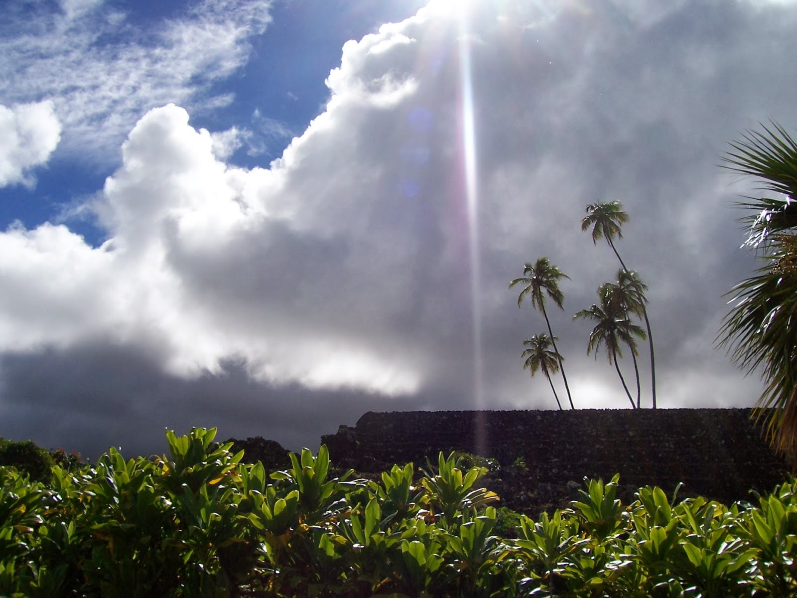
          The rays from between the grey clouds made picture taking a challenge. I kept shielding the lens with my left hand. Finally the spirits moved my hand so I could get the shot they wanted me to take.


I literally had shut the car door and the rain beat down on the roof and windshield--the gods had been waiting for me to get in our of the rain and turned on the faucet the moment I was safe. I laughed out loud--and thanked them for keeping me dry. The rain was pounding down so hard I could barely see the cement path--rain like I've only seen a few times before--a wall of water--like standing behind the waterfall.

Tuesday, July 9, 2013

Pohaku Ka Luahine

A beautiful summer morning on the hike up Moanalua trail in Kamana Nui Valley.  There is a little park at the trailhead.  Pueo-hulu-nui is where the owls of Kauai and Niihau gathered. 


This fireplace is on the left side of the road, just a little way up the hill. Nothing remains of the Douglas Damon house site except the fireplace and a small stone table.


There are several stream and bridge crossings on the way up the valley.  The Hawaiians said this pool had healing qualities and came here to bathe when they were recuperating from an illness.


These guardian rocks mark the way along the path. There are more guardian rocks near the actual stone.  Along the way I heard humming--an industrial sound. Since I was away from civilization, I couldn't figure out what I was hearing. On the way back, I noticed the power wires strung across the valley. The noise was coming from the wind in the wires. 


The name Pohaku Ka Luahine means Stone of the Old Woman. One tale told about this rock is that a child cried one night when a kapu was on at the heiau at the mouth of the valley. The consequence of anyone making noise during a ceremony was death. The child’s grandmother grabbed the infant and ran up the valley to the area called Kahukomo and hid behind the rock. Warriors searched for the woman and child but did not find them. After a few days, the kapu was lifted and they were able to return to their home.


The boulder is carved with petroglyphs, most of which are now so worn they are hardly visible.  


Monday, June 11, 2012

Maui No Ka Oi


I took my time and drove down to Nu’u Bay. I had been there a few years ago and had always intended to get back and spend some time. There was a large village of fishermen that lived there at one time: King Kekaulike and afterward, his son Kamehamehanui, both were in residence at different times.  I found the petroglyph field easily and began photographing. Was it the light, the squall that was brewing or the fact that the images had actually weathered that much in just a few short years? Whatever the reason, they were worn—the whole place was “worn”—just plum worn out. The sadness in the air, palpable.  This particular petroglyph caught my eye because it was the one that looked almost alive. Did its sense of being alive come from the way it had been drawn on the rock—had the artist really intended it to look so alien? Whatever it was, it stared at me with big round eyes—and stared and stared. I could hardly bring myself to move; I was transfixed for I don’t know how long.

I went on down to the rocky beach. The wind was whipping up the waves and when I looked to the left, I saw the squall racing toward me.  I snapped a couple of pictures and shoved my camera back in its case because the rain was upon me. In seconds I was drenched. The keawe thicket beckoned and I crawled under the branches to get out of the worst of the rain. 


 I stumbled through the grove until I found the trail again.  I looked down and saw blood running down my arm, mixed with rainwater and sweat.  It looks much more dramatic than it was.  When I got back to the car, I wiped my arm off with a Starbucks napkin and examined the small nick I’d gotten from the keawe thorn.  Yes, I had paid in blood, but it was a small price.


 Every time I looked in my rear view mirror, I could see the squall chasing me up the coastline.  I drove for a few miles and then stopped to take pictures of Kahaleamakani Gulch.  The road crew had put up the rock nets to protect what few travelers venture into these parts. Although I understand the danger falling rock represents (and almost was the victim of a boulder on the road one night near Hanauma Bay), I still look at those nets as putting the rocks behind bars.

When I got to the other side of the Gulch and up to a pull-out, the wind pushing the squall was right in my face. The closer I got to the edge of the cliff, the stronger the updraft until it was all I could do to stand up in order to take this picture.  Below there were lots of stone walls—windbreaks for the fishermen who camp down there in better weather.  Just that few minutes of picture taking and the squall had caught up with me again. 
I looked over to the slopes of Haleakala—which are behind the clouds that were scuttling along—seemingly as fast as I could drive.  I knew that somewhere behind all those clouds there was a 10,000 foot mountain.


 This is a small section of the King’s Road. Every year, the king would make his rounds of the island, collecting taxes.  As I flew in from Honolulu, I was also able to make out part of the king’s road around the Lahaina area. It’s easy to see once you know what you’re looking for.

I had always wanted to find the petroglyphs behind Buzz’s Steakhouse at Ma'alaea Bay. First I had to hop the traffic railing and wait until both lines of traffic allowed me to scurry across the road. I walked straight up the hill to the water tower. It was hot, the sun was beating down on my head (I hadn’t worn a hat because I figured I’d just be fighting the wind for my hat), and I had only a small bottle of water. The road went up at better than a 25 degree angle and my old body felt it!  I sat down and rested in the middle of the road, watching that same squall coming up the coastline.  I found some petroglyphs, but I’m not entirely certain they are the ones I’ve read about.  Nonetheless, here is one.

 The next day I drove my friends up to the crater.  Allison hadn’t been up there for years; D, the old horseman, used to take the tourists down in the crater in 12 person trail rides.  At about 8,000 feet Allison said she was feeling funny. By the time we got out of the car at a little over 10,000 feet, she was dizzy. We walked up the trail to the top of the rim. This is the Kaupo Gap—the place the last lava flowed out of the crater. In the distance is the Big Island—hidden in the clouds.


This is the Ko’olau Gap, the other flow went down the windward side.  When we were able to sit down on the boulder and get out of the wind, we tarried long enough to get a sense of the rarified air and the intense quiet (when the tourists weren’t jabbering). I had a small bag of potato chips in the car, and the bag swelled up with air until I thought for sure it would explode. I wanted to open it up there—just to see what would happen—but D said, “You’d have chips everywhere!” so I decided I’d watch the bag decompress on the way down.  I was busy driving and forgot to look until we were down to about 3,000 feet, and by that time it was almost back to normal.

Monday, May 21, 2012

Waimea Valley


I hadn’t been to Waimea Valley since I first came to O’ahu in 1981.  That day at Waimea was the first time I heard a conch shell trumpet, the first time I heard a chant in Hawaiian, and the first time I saw a kahiko hula.


My friend, Lani, said to be sure to look for the huge lily pads near the entrance.

A huge "happy" rock lives in the front of this hale and presumably guards the entrance.

Hewahewa, Kamehameha’s head kahuna (priest) spent his final days in Waimea Valley.  There is a place name of Waimea on all the major islands.  Waimea means red water. It was said that the water in the river was thought of as healing water due to the amount of iron in the soil.   


This rock, perched upon a much larger rock, could have easily been mistaken for a skull.  Whether it was placed there years ago, whether it has any meaning is not for me to say. Clearly the rocks are alive.

There were many rock paths and steps all over the gardens, leading to hales (houses) or sometimes they seemed to be steps to nowhere. I played around with photoshop on this picture, just to give it a very unworldly air--to show that things at the gardens were not always as they first seemed. It is a very magical place, if one but slows down to look and listen.

The vines growing around the base of this tree--and up into the branches--made me smile.  I was reminded of how I carefully tended this plant in order to make it grow indoors when I lived on the mainland.

There were many varieties of taro growing in the lo'i. I picked this one to photograph because the leaves where huge! 

Awa. The leaves and stems are chewed, then the juice is spit into a bowl, water is added. The whole concoction looks like mud and tastes bitter, so I'm told, but the effects are relaxing and prophetic. It was the sacred drink and used during ceremonies at the heiau


The outline of the man in the moss behind the red flower may have just been a fluke, but it reminded me to look for the spirits everywhere.


Waimea Valley was once a botanical garden before it became an adventure park.  It was finally purchased by OHA and is now a cultural site.  


The map says it’s about ¾ of a mile from the gift store to the waterfall.  At the bottom of the falls I took a dip—the cool water felt so good after the humid hike up to the back of the valley. 


This heiau is consecrated to the god Lono, the agricultural god.  Above this heiau—up on the bluff—is another heiau that was a luakini heaiu, or where they performed human sacrifices.