Saturday, May 28, 2011

Anaeho'omalu petroglyph field

This field—over 15 acres—is covered with the stories of the people of old. It was a very hot day as I made my way down the rocky path, stopping every step or two to take another picture. The sun beat down on me and I was glad I had remembered to slather on sunscreen and to bring water. I had not remembered a hat-- much to my dismay—and later realized my scalp was sunburned. All in a day’s work…


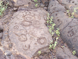
Some of these symbols are similar to Puu’ola petroglyphs down at the bottom of Chain of Craters Road in that there are many circles and crescents with holes in the middle—piko holes--signifying the birth of a boy (circle) or a girl (crescent).

There were several lava tubes where the people hid when the kings were fighting—a place for the general population to get out of the way—women, children and elders headed for these caves. The men were drafted into the king’s army, and either came back victorious or not. The petroglyphs were thick, thick, thick around the entrance to the caves. Not one on top of the other—they seemed respectful of what had already been drawn there—but a whole scramble of images right next to each other.

In one area the petroglyphs were surrounded by circles, as if to say “These pictures all belong together.”

These simple faces never cease to interest me. I have seen similar faces in the bottom of Canyonlands National Park in Utah, at Bellows Falls, Vermont, and now in Hawaii. Have always wondered about their alien quality and their similarity….

There are parts of the gray lava that seem to have cooled so fast that the color of the heat stayed in them. This petroglyph was red underneath—very striking-- and the one next to it, not. It seemed to be a natural part of the stone and not something man-made.

Puako Petroglyph field

Farther up the coast is the Puako petroglyph field. I was there in February, but this time I was able to spend several hours there photographing. The hike out is through the kiawe…there is a path of sorts. The petroglyph field is over a rise and down in a shallow gully. My guess is that there were petrogylph fields all along the coastline: Puako, Anaeho’omalu, and Ka’upulehu are the fields that are left after the a’a flowed down the mountainside. I tried, but was unable to go to Ka’upulehu--Kona Village resort was closed due to tsunami damage.

In this petroglyph field there are many complete bodies—as opposed to the piko holes at Anaeho’omalu field, farther south along the coast. There are many three-toed bodies with long tails at this site—I have been told they symbolize the mo’o. There were also many ‘bird’ symbols—like a bird in flight—simply the wings and the body.

This man seems to be holding a crescent in each hand. The crescent was the sign of the moon goddess, Hina.

Moku'ohia Battleground and Kealakekua Bay


Moku’ohai Battleground is where Keeaumoku slashed Kiwala’o’s throat open as he bent down to retrieve the precious necklace. The death of Kiwala'o (Kalani’opu’u’s son) paved the way for Kamehameha to begin his serious challenge to the kingdom. I drove up and down the back road, looking for this battleground. When I stopped for breakfast at The Coffee Shack, it became very apparent to me why I couldn’t find it—a’a looks a lot alike up close. It was only as I was able to look down upon the area that I could see the extent of the battlefield laid out below me--the brown area in the middle--fighting in the middle of the a'a flow.


I rented a single kayak and paddled across Kealakekua Bay, deciding as I went that this would be my (late) birthday celebration. I pulled the kayak up into the trees and tied it up. I stashed my snorkel gear and my lunch and walked around the area, knowing that this is where my sacred queen, Kalola, was with her husband Kalani’opu’u the day Captain Cook was killed. It was Kalola, in fact, who begged her husband not to go with Cook. Cook was planning to kidnap the king and hold him for ransom in order to get back a shore boat which has been taken apart for the metal.

This path led up the hill--the hill I avoided traversing because I had rented the kayak and paddled. There are stone walls everywhere—it must have been a large village at one point. Fresh water would have been gotten from the springs in the bay.


This site had beautiful flowers everywhere and I decided this would have been the perfect site for a lovely house overlooking the bay.

Cook’s monument. This little bit of fenced-off soil actually belong to England. In the background, the cliffs of Keoua.


I snorkeled along the coastline with the tourists. The smoke coming from this boat was the hamburger grill being fired up. I was glad to see that the dive boats come to this area—the drop-off is so deep that the tourists are unable to wedge their fins in the coral and can’t damage it. The snorkeling is superb. At one point I saw a school of 200 yellow tang feeding. This basalt outcropping stretches over halfway across the bay and there are many burial caves in the cliffs. How they ever got up to those caves was a miracle—and the story is that if a man carried somone’s bones up there, he had to die so that no one would know where the bones of the ali’i was buried.