Wednesday, June 1, 2011

Waipio Valley

My first trip into Waipio Valley—the Valley of the Kings. The travel brochures say it’s 1200 feet down in about a mile. I don’t know which is worse—going down or coming back up. I guess it depends on the state of your knees and lungs. Suffice it to say, I didn’t go down without help. I took a van down and then went on the mule-drawn wagon tour. Two mules pulled the wagon with 10 of us aboard. Bob, the muleskinner, said mules are much stronger than horses—and much smarter. When they get tired, they quit (that would be the smarter part…)


Looking up the valley—one way in and one way out of the valley. Back in the valley is more taro patches and private land. Bob said most of the people live back in the valley—very primitive back there. Near the mouth of the valley there is electricity. Further up, it’s solar power, propane or candles. In order to get back in the far part of the valley, you have to cross five streams. The mules grudgingly took us through two.

Hi’ilawe Falls marks the 1200 feet drop—tallest waterfalls in all the islands. There has been a drought the last several months, so there hardly any water coming over the falls. The top part of the falls had a little water, but by the time it got to the bottom layer, it was hardly getting the rocks wet.

Some families grow taro, but aren’t always around to tend the patches, which grow up with weeds in no time. The taro is for family use only—no commercial enterprises growing taro. In Kamehameha’s time, Captain Cook estimated there were 20,000 people living in the valley. Tsunamis and floods wipe things out occasionally. The last big population was estimated at 3,000—pre tsunami in the ’60’s. After the tsunami, no one. Slowly the population has grown to about 50 full-timers now.

My friend Lani’s father won a little piece of the valley in a poker game. There used to be a small house, but it burned down. Now there is a tree to mark the spot.

Saturday, May 28, 2011

Anaeho'omalu petroglyph field

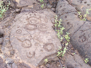
This field—over 15 acres—is covered with the stories of the people of old. It was a very hot day as I made my way down the rocky path, stopping every step or two to take another picture. The sun beat down on me and I was glad I had remembered to slather on sunscreen and to bring water. I had not remembered a hat-- much to my dismay—and later realized my scalp was sunburned. All in a day’s work…


Some of these symbols are similar to Puu’ola petroglyphs down at the bottom of Chain of Craters Road in that there are many circles and crescents with holes in the middle—piko holes--signifying the birth of a boy (circle) or a girl (crescent).

There were several lava tubes where the people hid when the kings were fighting—a place for the general population to get out of the way—women, children and elders headed for these caves. The men were drafted into the king’s army, and either came back victorious or not. The petroglyphs were thick, thick, thick around the entrance to the caves. Not one on top of the other—they seemed respectful of what had already been drawn there—but a whole scramble of images right next to each other.

In one area the petroglyphs were surrounded by circles, as if to say “These pictures all belong together.”

These simple faces never cease to interest me. I have seen similar faces in the bottom of Canyonlands National Park in Utah, at Bellows Falls, Vermont, and now in Hawaii. Have always wondered about their alien quality and their similarity….

There are parts of the gray lava that seem to have cooled so fast that the color of the heat stayed in them. This petroglyph was red underneath—very striking-- and the one next to it, not. It seemed to be a natural part of the stone and not something man-made.

Puako Petroglyph field

Farther up the coast is the Puako petroglyph field. I was there in February, but this time I was able to spend several hours there photographing. The hike out is through the kiawe…there is a path of sorts. The petroglyph field is over a rise and down in a shallow gully. My guess is that there were petrogylph fields all along the coastline: Puako, Anaeho’omalu, and Ka’upulehu are the fields that are left after the a’a flowed down the mountainside. I tried, but was unable to go to Ka’upulehu--Kona Village resort was closed due to tsunami damage.

In this petroglyph field there are many complete bodies—as opposed to the piko holes at Anaeho’omalu field, farther south along the coast. There are many three-toed bodies with long tails at this site—I have been told they symbolize the mo’o. There were also many ‘bird’ symbols—like a bird in flight—simply the wings and the body.

This man seems to be holding a crescent in each hand. The crescent was the sign of the moon goddess, Hina.

Moku'ohia Battleground and Kealakekua Bay


Moku’ohai Battleground is where Keeaumoku slashed Kiwala’o’s throat open as he bent down to retrieve the precious necklace. The death of Kiwala'o (Kalani’opu’u’s son) paved the way for Kamehameha to begin his serious challenge to the kingdom. I drove up and down the back road, looking for this battleground. When I stopped for breakfast at The Coffee Shack, it became very apparent to me why I couldn’t find it—a’a looks a lot alike up close. It was only as I was able to look down upon the area that I could see the extent of the battlefield laid out below me--the brown area in the middle--fighting in the middle of the a'a flow.


I rented a single kayak and paddled across Kealakekua Bay, deciding as I went that this would be my (late) birthday celebration. I pulled the kayak up into the trees and tied it up. I stashed my snorkel gear and my lunch and walked around the area, knowing that this is where my sacred queen, Kalola, was with her husband Kalani’opu’u the day Captain Cook was killed. It was Kalola, in fact, who begged her husband not to go with Cook. Cook was planning to kidnap the king and hold him for ransom in order to get back a shore boat which has been taken apart for the metal.

This path led up the hill--the hill I avoided traversing because I had rented the kayak and paddled. There are stone walls everywhere—it must have been a large village at one point. Fresh water would have been gotten from the springs in the bay.


This site had beautiful flowers everywhere and I decided this would have been the perfect site for a lovely house overlooking the bay.

Cook’s monument. This little bit of fenced-off soil actually belong to England. In the background, the cliffs of Keoua.


I snorkeled along the coastline with the tourists. The smoke coming from this boat was the hamburger grill being fired up. I was glad to see that the dive boats come to this area—the drop-off is so deep that the tourists are unable to wedge their fins in the coral and can’t damage it. The snorkeling is superb. At one point I saw a school of 200 yellow tang feeding. This basalt outcropping stretches over halfway across the bay and there are many burial caves in the cliffs. How they ever got up to those caves was a miracle—and the story is that if a man carried somone’s bones up there, he had to die so that no one would know where the bones of the ali’i was buried.

Saturday, April 23, 2011

Kumukahi

Out at the parking area at the lighthouse--Kumukahi--the eastern tip of the Big Island. The road out--after I got off the paved road--is washboard gravel. Not bad, but it would definitely discourage the average tourist. On my way in, I passed a hula halau--two vans and a red car--filled with women. It's the opening of Merrie Monarch tomorrow--the ladies out exploring made me smile. I parked, gathered, my camera and some water in a bag and headed out across the a'a and pahoehoe lava. Then I had to come back because I remembered I had printed off a chant from the internet. When I had myself together: my hat on, slathered with sunscreen, and some water, I was ready. There was somewhat of a trail--at least in the beginning. I had on my slippers, so it was slow going, which was fine--I was in no hurry.

It's maybe a quarter of a mile out to the 'road' that runs along the shoreline/cliff. I use the term 'road' loosely--it may be the old King's trail now turned into a fisherman's road--no wonder they all have four wheel drive vehicles and those enormous tires. I saw two big outcroppings and headed for them, thinking they must be the pillars--the chief's wives of the legend--and they very well may have been because he was reputed to have four wives. These seem to have been two of them--and later I met two more.


After I got down to the road along the cliff--barely passable by jeep--I turned left and walked down the 'road'. I saw a man-made cairn with an orange lei on it. At the bottom were two bleached-out caps and two cement markers that say, "We love you papa." I walked up a little rise, thinking I would just go to the top of the rise to see if where was anything interesting: a little rocky beach, some ironwood trees, and the hidden stone wall of Kumukahi heiau. It says in the guidebook that it is pretty well overgrown and destroyed. There was a small palm tree in the middle and from the outside it kept waving at me--not wanting me to lose track of it. Every time I would look away, its energy would pull me back. At first I thought maybe someone was camping out there and moving about, thereby rustling the tree. But upon closer investigation, there was no one there--just the tree inviting me for a closer look. I went to the left of the outcropping of trees--out to the point, which is, literally, the easternmost point of the island. Relatively speaking, it was a calm day on the ocean. Nevertheless, the waves coming in and crashing on the rocks are quite strong--beautiful without a doubt--but strong. Then I walked back toward the stand of trees and inched my way up to the wall along a path. Right at the spot the wall was broken, and peering in through the low-hanging hau branches, it looked more like a fisherman's camp than a sacred heiau.

I stopped and asked permission to enter. Not sensing any resistance, I walked around the spreading tree, all the while moving very slow and looking for signs I would not be welcome. I walked through the middle and out the south side. It is said that the two stones on the shoreline marked the winter and summer solstices and that the heiau had been used for training navigators. The sun rise every morning makes sense... I sat down on a big stone and read to the spirits there--a chant from the kumu hula de Silva--one that she made accessible on the internet-- along with its history and the translation and notes. First I apologized for to any spirits that may have been about for bungling the language so bad, for my spoken Hawaiian is dismal, at best. At my worst, I'm sure I mangle the words so bad that the spirits could never figure out what I'm trying to say. I read along, feeling like I was reading a first grade primer. I'd sound out what I thought was a word and then I'd go back over it and pronounce it easier--as if they were aunties/ teachers looking over my shoulder and helping me out in the worst spots. At times I could almost hear them giggling as I struggled along, determined to read to the end.
As I was coming back along the 'road' on the cliffside, a blue pickup with three young men came bumping along. I stepped off the road and let them pass. After they went by, I chuckled to myself. Here I am with my salt and pepper hair, in a dress, out trapsing through the lava in my slippers. In another day and time, among the superstitious, I could be the incarnation of Madame Pele--an old lady walking along the shoreline by herself. (too bad I never have one white poi dog...) I found the spot along the road where I had come from and headed back in the direction of the lighthouse. As with every trip, it always takes longer to get there than it does to come back.

As I sit here on the side of the hill I can plainly see the ironwood trees that mark the heiau site. Did I see them on my way out there? No. I stumbled on the site by blind luck (mine) and/ or the direction of the infinite (the spirits).
It is said that the heiau was a place where the priests manufactured poison, and that it was a place of interest to King David Kalakaua, who came out and got the flat stones from the floor of the heiau to use as part of the foundation for the 'Iolani Palace.


Sunday, April 10, 2011

In the Footsteps of Keoua

Today I took a drive to the trailhead of the Ka'u desert trail. I wanted to see the footprint of the man who had dodged the lava and made it all the way to Ka'u through the lava desert. First there was a path through the a'a lava--jagged and rough. Then a slight downhill section and then the ropey pahoehoe lava, broken only by a few ohia trees, the trees of Madame Pele. Just a few feet from the highway, I completely lost sight of the road and followed the cairn-marked path through the lava. It was quiet--just a gentle breeze at first, enough to cool me. I was grateful for the scattering of clouds, keeping the sun from cooking me as in an imu. I looked for footprints all along the trail, amazed that anyone could find their way through the maze of lava.


I would like to pretend this footprint is from the king--King Keoua, although there is nothing in the world that would support that--just my imagination. After a battle with Kamehameha, one which neither side won, Keoua retired to Hilo, then decided to head down to Ka'u by way of Ola'a, past the crater of the volcano. He divided his retinue into three groups. The first group made it through the eruption, the second group succumbed to the sulfur dioxide and died where they fell--men, women and children lying unmutilated. The third group found the second. This footprint is bigger than it looks...I waved my size 9 1/2 (but a 10 feels sooo good) shoe over the top of this footprint--and it is easily a 14. Made my foot look dwarfed beside it. And to think that all they were wearing was hemp sandals. As I looked over the Ka'u desert, I marveled at how badly those folks must have wanted to get home--it wouldn't be the route I would have chosen--not by any means.


By the footprints are these "creatures"--pahoehoe lava frozen into shapes that resembled idols, watching over the souls of the people who succumbed to the sulfur from the erupting volcano. The wind blew, the black sand scuttled across my shoe, and yet it was quiet. Nothing moved--not a bird, not a lizard, not a bug. It is truly desert--and deserted. Eerie...

Friday, February 25, 2011

Mo'o, Petroglyph, and a Dead Chief

Let me explain: this is my shadow—over a petroglyph at Puako. The shadows of the late afternoon lengthened along the trail, kiawe bushes snagging my dress, and sweat poured down my face as I hurried to the petroglyph field. Images hammered out in the lava—hundreds, no thousands. The more I explored, the more I saw. Every angle, every nitch, every bare spot filled with images—mainly people, primarily men; some with arms raised, others with arms lowered. Clearly there was the image of a dog, perhaps a spider, a sail, children, women in the act of birth--the story of a people saved in stone. What I thought would be a quick study turned into the realization that I would be coming back again and again—there is no quick study. There is much work to be done if I am to understand. Much work… and so to unite myself with the work, the image, the thought, the mana, I offered myself to the image. I too, am now a part of that field…and it a part of me.

This is the pond where the mo’o lives at Honanaunau. She is still there—see her making the ripples on the surface of the pond?

Years ago I visited Pu’uhonua o Honanaunau—the last residence of King Kamehameha I. Now that I have been studying Hawaiian history for the past two years, I am beginning to understand what I am seeing—if only through the glass, darkly. Now it is called “the place of refuge.” If a man could run miles across the lava, swim across a shark infested bay, crawl out on the shore, then only if he could make inside the doors of the heiau would he be safe. The idols are in place, next to the sacrificial altar. This day—and for many years past now—the altar was empty, but it was not always so. When the priests deemed it necessary, not only world worldly goods be placed on the altar—bananas, coconuts, a roasted dog or pig, so would they have also sacrificed a man.

On the ocean side of Ke’eku heiau, near the Outrigger Hotel at Keauhou Bay, I walked through the tide pool to get to the petroglyph of the Maui chief, Kamalalawalu. This king got some bad information from his scout and set out from Maui to conquer the Big Island. Alas, many warriors were hiding and the Maui chief was soundly defeated. The captured chief was tortured and finally beheaded before being offered up as a sacrifice.