Wednesday, June 29, 2011

Ulupo Heiau Kailua, O'ahu

This heiau is just off a main thoroughfare near the city of Kailua. I don’t know how many times I have been by this place and because of heavy traffic totally missed seeing it. Legend has it (in other words, no one knows for sure) that it was built by the menehunes (the little people of the islands) way before contact with even the Tahitians. Now, that’s going back a far piece… This top level of the heiau is 140 feet by 180 feet. It sits up on a plateau and from the bottom it is overwhelming. It is located right behind the Y—or, rather I guess it would be more correct to say that the Y built near it—the heiau being first on the scene by maybe 1,000 years and the Y an interloper, as it were. The chattering of children broke the silence, which is probably delightful to the spirits—they seem to like the laughter of children. In the distance are the Oneawa Hills between the towns of Kailua and Kaneohe.
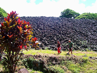
This is taken from the bottom of the heiau—the easternmost side. I was glad that the two people were walking through—gives some idea of how tall this heiau is—a full 30 feet the guide book says, and I would say it looks every bit of it and then some. I was standing across the stream when I took his picture. After I explored a bit, I came back along the path that these folks are walking and looked up the pile of rocks. It was breathtaking—quite an enormous amount of stone. The plants in the foreground are red ti. Ti is considered a spiritual plant—very cleansing.
The flat stones are lined up in a double row and lead down to a spring at the northwest corner of the heaiu. This is the “Menehune Pathway”. The menehune—the little people—are said to have built this heiau by carrying stones from Kualoa, or from Ewa or from as far away as Waianae. If the last two quarry sites are true, then the stones had to be transported over the Pali. From any of the mentioned sites, the stones traveled a long way.
There are two small pools, each about three feet wide, where it is said the priests brought the pigs to be washed before they were sacrificed on the altar of the heiau. The shadow in the water? Mine.
It is thought that this heiau might have been used for agricultural purposes due to the fact that the taro patches are right below it. That would make the taro patches as old as the heiau. In the middle of the picture are a couple of banana trees, and on either side, coconut palms. Even though it was close to the thoroughfare—I could hear the swish-swish of tires on the asphalt and see the cars driving by, it was quiet and peaceful in the taro patch. This is definitely a place I will return.

Pandanas, lauhala, and screwpine are just a few of the names of this plant, which is found all over the South Pacific. The weavers go through a long process—picking up the fallen leaves, taking off the thorns on the edges, washing the leaves, then boiling them, letting them dry, cutting them into the desired width—all to make a hat or mat, basket or sail for the voyaging canoe. One of my students said that the people of Puna, on the Big Island, have eyelashes like lauhala. I looked in her beautiful eyes and saw the same curve. “I take it you’re from Puna?” She just smiled. Another student did a report on lauhala and told of it’s many uses—would that I remembered more…

Monday, June 13, 2011

Cock-a-doodle-do!


“Cock-a-doodle-do!”

‘Cock-a-doodle do?’ I thought to myself. ‘There must be some mistake. ‘ It had, indeed, been one of those peculiar days when the negative ions had been running amok since breakfast and things were more bizarre than usual. I looked around for said fowl, and seeing none, I proceeded to let the door shut behind me. I noted the slots for outgoing mail directly in front of me, turned 90 degrees to my right and spotted a long line of silver mailboxes, turned another 90 degrees and saw a display of packaging material and a tall metal waste basket. Someone had swiped the pen from the chain attached to the counter—again. It looked like I was standing in the middle of the post office all right, but just to make sure, I went back outside and looked at the sign on the side of the building: Airport Branch, United States Postal Service. Thus assured, I opened the door again.

“Cock-a-doodle-do!”

This time the cry came a little fainter--from the back of the chicken coop—I mean, the package handling area. The other people standing in line didn’t seem to be bothered by the rooster chorus, so I shrugged it off. Still, I wasn’t completely convinced that I hadn’t somehow mistakenly opened the door to the back of the barn. I surveyed the postal workers behind the long counter, each at their appointed cubical, carrying on as if there was nothing out of the ordinary—as if it was just another day of selling stamps, and handling packages coming and going…

“Cock-a-doodle-do!”

Through the very door I had just entered came a large crate, “Live animal” lettered on the side of the cardboard box. Two beady eyes peered through the air holes of the crate. Below the crate, an extended paunch, a precarious place for balancing said crate, but utilized to the fullest, nonetheless. Beneath the paunch, two stubby legs ended in a pair of black zori slippers. Junior Boy, obviously an old hand at this maneuver, swung the crate around and hefted it up on the postal scale in one smooth motion.

“Cock-a-doodle-do!”

From my place in line, I could look behind the cashier and see a cart with several crates lined up, and gauging from the racket, all filled with roosters. The bird on the scale pecked at the side of his carton, desperate to escape the dark prison of cardboard, threatening to get at his brethren and tear them to shreds.

“Cock-a-doodle-do—you son of a bitch. If I ever get out of this joint and get my hands on you I’ll….”

“You and who else?” The second bird answered.

From the back room came a muffled, “Who’s your muther?”

Junior Boy made a hasty retreat through the door and left the handling of the bill to an older man. Uncle Junior wore a sleeveless t-shirt with the logo Club Femme Nude on the back. It might as well have said, “Live animal,” the same as the crate, because the logo of a naked lady, her legs curled around a stripper pole, spoke volumes as to the character of the establishment. Birds of a feather, as it were. Uncle Junior expertly handled the monetary end of the transaction, making sure that he rested his hands under the crate at an angle the postal worker couldn’t see and ever so slightly tipping the crate and rooster up in order to subtract a few ounces from the weight of the bird, as if the weighing in of the rooster equated a prize fighter being weighed before a match. For, in truth, that is exactly what was happening—these birds had been bred for one of the island’s national pastimes: cockfighting. Legally, the birds could be shipped for breeding purposes, but honestly, Uncle Junior and Junior Boy didn’t look like they’d seen the sunny side of the law for years—indeed, Junior Boy was learning from an old pro.

“Cock-a-doodle-do!”

Junior Boy brought in yet another crate. Uncle Junior parked his fingers in just the right spot, the postal clerk weighed the bird, and the roosters (none plucked for eating) piled up higher and higher in the back room. I bought my stamps, hoping I could get out before one of the workers (a very long afternoon stretching out in front of them) went postal. What can I say?

“Cock-a-doodle-do!”

It’s just another day in Hilo…..

Thursday, June 9, 2011

Pu'u Loa petroglyphs

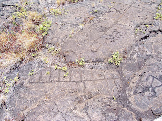
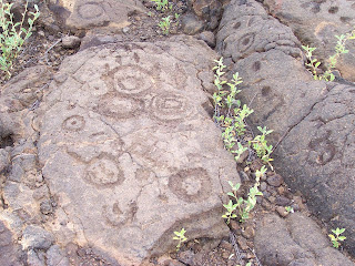
This photo is very typical of the number, size and variety of the petroglyphs at this site near the bottom of Chain of Craters Road. And yet, there are strange elements: the straight line with the sidebars in the bottom of the picture, the “sail” in the middle of the picture, and the “star” pattern beyond. What is typical is the number of piko holes—the circles with the holes are said to represent boys, a crescent represents a girl. Not all holes have a gender determiner. It is said that the father took the umbilical cord out to this site, make a petroglyph to honor his child, put the umbilical cord in the hole and left. When he returned days later, if the umbilical cord was gone, it meant the gods accepted the child and it would live. Maybe the father only made the sign of the boy or girl when it was determined the child would live. (That is purely speculation on my part….)

This rock outcropping caught my eye from afar—it is not “on the beaten trail” and neither was I. What astounds me about this imagine is the red on the rock—that seemingly bleeds through from the molten lava. I also love the idea of this ledge of pahoehoe lava just stopping at this particular place and forming a perfect canvas.

Several of the human images had a circle above or near the head.

These “twins” stand out—they are carved deep into the lava, surrounded by other human figures and many, many piko holes and circles.

This image haunts me because I’ve not seen anything like it anywhere else. It is off by itself, along a pahoehoe tongue. The lava just to the right is rippled, but this one spot made a perfect place to carve.

Another typical section of petroglyphs at this site. Since I had seen the encompassing circle around some of the petroglyphs at another site and noted it for the first time, I was surprised—and pleased—to note it again. At this site there were also several circles that were connected, forming “handcuffs”. There are two examples in this photo.

Three human figures, all with their arms in the “down” position, but arms curved, not like the stick arms at other sites. Only one man has a piko hole in his chest.

This “rose” was another one off the beaten path. As I was leaving, I walked slow and kept looking around for other images. I was not disappointed. This one is up on the top of a low ridge. As soon as I spied it up there, I had to find a way to scramble up and photograph it—quite unusual.

I drove up to Volcanoes National Park, wondering all the way if I should turn around and bag the day—the weather was sketchy at best, and the weather report said “40% chance of rain and/ or thunderstorms.” I figured that I had a couple of hours midday that I might find some decent weather, so I kept driving through the mist at the 2,000 foot level. Even on the way down the other side of the ridge--on the dry side--I had my doubts. The rain forest, of course, was rainy—and windy, and I thought many times about turning around and eating my sandwich somewhere else, but, something kept pulling me on. Down on the plain near the ocean the weather was cloudy but not raining. I grabbed my camera and a bottle of water and headed out. Photographed as fast as I could, knowing my time out there would be limited. After about an hour I got sprinkled on and I had to stop and beg the gods for just a little more time, please... They relented and stopped the rain…but as I looked over my shoulder into the wind, I knew I had to work fast--I would not be granted much more time because Mother Nature had work to do. This is the path on the way back to the car—the mist was, literally, chasing me. I threw my camera in the car, talked to some tourists who were headed out to the field, then got in the car. Just as I shut the door, the rain pelted the windshield and I thanked my lucky stars.

Wednesday, June 1, 2011

Waipio Valley

My first trip into Waipio Valley—the Valley of the Kings. The travel brochures say it’s 1200 feet down in about a mile. I don’t know which is worse—going down or coming back up. I guess it depends on the state of your knees and lungs. Suffice it to say, I didn’t go down without help. I took a van down and then went on the mule-drawn wagon tour. Two mules pulled the wagon with 10 of us aboard. Bob, the muleskinner, said mules are much stronger than horses—and much smarter. When they get tired, they quit (that would be the smarter part…)


Looking up the valley—one way in and one way out of the valley. Back in the valley is more taro patches and private land. Bob said most of the people live back in the valley—very primitive back there. Near the mouth of the valley there is electricity. Further up, it’s solar power, propane or candles. In order to get back in the far part of the valley, you have to cross five streams. The mules grudgingly took us through two.

Hi’ilawe Falls marks the 1200 feet drop—tallest waterfalls in all the islands. There has been a drought the last several months, so there hardly any water coming over the falls. The top part of the falls had a little water, but by the time it got to the bottom layer, it was hardly getting the rocks wet.

Some families grow taro, but aren’t always around to tend the patches, which grow up with weeds in no time. The taro is for family use only—no commercial enterprises growing taro. In Kamehameha’s time, Captain Cook estimated there were 20,000 people living in the valley. Tsunamis and floods wipe things out occasionally. The last big population was estimated at 3,000—pre tsunami in the ’60’s. After the tsunami, no one. Slowly the population has grown to about 50 full-timers now.

My friend Lani’s father won a little piece of the valley in a poker game. There used to be a small house, but it burned down. Now there is a tree to mark the spot.

Saturday, May 28, 2011

Anaeho'omalu petroglyph field

This field—over 15 acres—is covered with the stories of the people of old. It was a very hot day as I made my way down the rocky path, stopping every step or two to take another picture. The sun beat down on me and I was glad I had remembered to slather on sunscreen and to bring water. I had not remembered a hat-- much to my dismay—and later realized my scalp was sunburned. All in a day’s work…


Some of these symbols are similar to Puu’ola petroglyphs down at the bottom of Chain of Craters Road in that there are many circles and crescents with holes in the middle—piko holes--signifying the birth of a boy (circle) or a girl (crescent).

There were several lava tubes where the people hid when the kings were fighting—a place for the general population to get out of the way—women, children and elders headed for these caves. The men were drafted into the king’s army, and either came back victorious or not. The petroglyphs were thick, thick, thick around the entrance to the caves. Not one on top of the other—they seemed respectful of what had already been drawn there—but a whole scramble of images right next to each other.

In one area the petroglyphs were surrounded by circles, as if to say “These pictures all belong together.”

These simple faces never cease to interest me. I have seen similar faces in the bottom of Canyonlands National Park in Utah, at Bellows Falls, Vermont, and now in Hawaii. Have always wondered about their alien quality and their similarity….

There are parts of the gray lava that seem to have cooled so fast that the color of the heat stayed in them. This petroglyph was red underneath—very striking-- and the one next to it, not. It seemed to be a natural part of the stone and not something man-made.

Puako Petroglyph field

Farther up the coast is the Puako petroglyph field. I was there in February, but this time I was able to spend several hours there photographing. The hike out is through the kiawe…there is a path of sorts. The petroglyph field is over a rise and down in a shallow gully. My guess is that there were petrogylph fields all along the coastline: Puako, Anaeho’omalu, and Ka’upulehu are the fields that are left after the a’a flowed down the mountainside. I tried, but was unable to go to Ka’upulehu--Kona Village resort was closed due to tsunami damage.

In this petroglyph field there are many complete bodies—as opposed to the piko holes at Anaeho’omalu field, farther south along the coast. There are many three-toed bodies with long tails at this site—I have been told they symbolize the mo’o. There were also many ‘bird’ symbols—like a bird in flight—simply the wings and the body.

This man seems to be holding a crescent in each hand. The crescent was the sign of the moon goddess, Hina.

Moku'ohia Battleground and Kealakekua Bay


Moku’ohai Battleground is where Keeaumoku slashed Kiwala’o’s throat open as he bent down to retrieve the precious necklace. The death of Kiwala'o (Kalani’opu’u’s son) paved the way for Kamehameha to begin his serious challenge to the kingdom. I drove up and down the back road, looking for this battleground. When I stopped for breakfast at The Coffee Shack, it became very apparent to me why I couldn’t find it—a’a looks a lot alike up close. It was only as I was able to look down upon the area that I could see the extent of the battlefield laid out below me--the brown area in the middle--fighting in the middle of the a'a flow.


I rented a single kayak and paddled across Kealakekua Bay, deciding as I went that this would be my (late) birthday celebration. I pulled the kayak up into the trees and tied it up. I stashed my snorkel gear and my lunch and walked around the area, knowing that this is where my sacred queen, Kalola, was with her husband Kalani’opu’u the day Captain Cook was killed. It was Kalola, in fact, who begged her husband not to go with Cook. Cook was planning to kidnap the king and hold him for ransom in order to get back a shore boat which has been taken apart for the metal.

This path led up the hill--the hill I avoided traversing because I had rented the kayak and paddled. There are stone walls everywhere—it must have been a large village at one point. Fresh water would have been gotten from the springs in the bay.


This site had beautiful flowers everywhere and I decided this would have been the perfect site for a lovely house overlooking the bay.

Cook’s monument. This little bit of fenced-off soil actually belong to England. In the background, the cliffs of Keoua.


I snorkeled along the coastline with the tourists. The smoke coming from this boat was the hamburger grill being fired up. I was glad to see that the dive boats come to this area—the drop-off is so deep that the tourists are unable to wedge their fins in the coral and can’t damage it. The snorkeling is superb. At one point I saw a school of 200 yellow tang feeding. This basalt outcropping stretches over halfway across the bay and there are many burial caves in the cliffs. How they ever got up to those caves was a miracle—and the story is that if a man carried somone’s bones up there, he had to die so that no one would know where the bones of the ali’i was buried.